Trip Report
May-June, 2008
Big Western National Parks Loop
Overview
This year we did another driving trip. We hit some old favorites and some things we hadn’t had a chance to go to before. We worked basically south to north since it was early in the season and we wanted to get the southern stuff before it got too hot but give the northern stuff a chance to warm up a bit. This was only partially successful since the northern areas were having a cold and wet year but it still beat the alternative.
One little thing I added this year was that I carry a pedometer. It works really well – it’s not like the old ones. It’s not quite as accurate on hills but it should give some idea in terms of which days were more walking around and which ones were more driving. It’s not always obvious from the descriptions because if there were a bunch of short walks to views they can really add up. Just for comparison I try to walk 10,000 steps a day.
Please note that although this does include a couple of maps it doesn't contain photos - hopefully those will come later.
Sunday, May 25th, 2008 – San Francisco, CA to Ridgecrest, CA
5,469 Steps
The first day we had some odd timing – we left for a three week trip on a late Sunday. We did this because I wanted to go to Carnaval Sunday morning. San Francisco has Carnaval oddly late in the year because it’s just too darn cold earlier in the year.
The rest of the day was basically driving – we couldn’t make it as close to Death Valley as we’d like, but we’d at least get in the ballpark. Ridgecrest is a nice enough town that’s about six hours away from San Francisco and maybe two hours from Death Valley. That’s as close as we were going to get with such a late start. The good news is that this Sunday was the Sunday before Memorial Day which is a very light traffic day, so we could zip down the I-5 without a whole lot of grief.
Monday, May 26th, 2008 – Ridgecrest, CA to Death Valley, CA to Las Vegas NV
17,696 Steps
Basically the point of this day was to just get a taste of Death Valley on the way to Vegas and decide if we wanted to make a longer trip of it some other time. If you’re a hiker or photographer you can spend pretty much as much time as you would like, but it’s still interesting even if you just have a bit of time.
The whole drive over is actually pretty interesting in of itself – I’m glad we did it in the morning instead of the prior evening – very pretty countryside (at pullouts you would find German tourists taking each others picture in front of sweeping vistas) and in one area giant piles of salt from a mining operation.
The basic plan was to take the 190 across Death Valley, detouring to Badwater (and hitting any short hikes along the way that looked fun) and detouring again to Dantes View and then getting to Vegas as late as necessary. That’s pretty much what we did – and generally had a good time. There are sand dunes to play in, ruins from the borax mining days, a salt creek with little pupfish somehow surviving in it, and Badwater itself which is hundreds of feet below sea level. We got to Dantes View a little late for the full effect (it’s better morning or afternoon) but still worth the detour.
From there it’s another couple of hours to Vegas, so as you might imagine we were pretty tired of driving by then.
Tuesday, May 27th, 2008 – Las Vegas, NV
22,031 Steps
We’re not exactly Vegas people but I enjoy it in small doses. If you don’t gamble or drink or like crowds that’s not such a good start, and we’re not as impressed with the shopping, food, or shows as somebody from a small town would be (as an example, Vegas has lots of Cirque du Soleil shows but San Francisco is always the first US stop after a short Canadian run for all of their touring shows and we've seen a ton of them). But there’s a ton of things to do and the people watching is interesting and there are enough quirky shows that we could find something. (The Mac King comedy magic show is very good if you want an afternoon show).
We stayed in Paris simply because we thought it looked fun last time and it’s centrally located and it was pretty cheap – Vegas is expensive Memorial Day weekend but arriving the day after Memorial Day everything’s pretty reasonable. It was fine, and fun for a day but I think any of the themed hotels would drive me crazy in pretty short order.
Wednesday, May 28th, 2008 – Las Vegas NV to Hoover Dam to the Grand Canyon, AZ
10,081 Steps
In a sense this was just a repositioning day, trying to get to the Grand Canyon, ideally with it still light enough to see something. This is a bit trickier than it sounds, because sunset is pretty early and once the sun is pretty close to the horizon much of the canyon is in shadow. The route also takes you over Hoover Dam and even if you just park and walk along the dam and back and don’t do any of the tours it takes an hour or so. Luckily we’d been there before, back when they offered the hardhat tour, and had access like you can’t get anymore with the new security issues. But they are offering what sounds like some nice tours so I’d allow plenty of time if you’re at all interested in dams – you can see some of the power generation stuff, as an example.
And we did in fact get to the canyon early enough to check it out a bit and take a few pictures but if we’d stopped and checked into our hotel we probably would have missed it – it was a pretty close situation. We stayed in the park at the Yavapai lodge which is not on the rim itself (so it’s cheap!) but has a convenient location.
Thursday, May 29th, 2008 – Grand Canyon, AZ
26,211 Steps
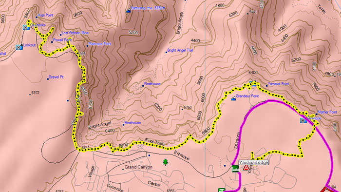
This was basically our day to enjoy the view. We were going to do a slightly different rim hike, but due to some road closures we hiked from our room to Mather Point and then along the rim to Hopi point and then back on the shuttle. I had my GPS on – it tells me we hiked 7.2 miles in 4.5 hours. Not exactly a fast pace but we weren’t adjusted to the altitude and there’s a whole lot of stopping to take pictures, snack, look at occasional exhibits, etc. Luckily it wasn’t too hot although it was windier than I’d like standing on a drop like that!
Friday, May 30th, 2003 – Grand Canyon to Zion NP, UT
6,959 Steps
This was fundamentally a repositioning day, but we took our time leaving the Grand Canyon, stopping at all the view areas. We also stopped briefly at Parker Dam which was pretty. We were staying in Springdale which is outside the park but shuttles run to and from there and the visitor’s center and from the visitor’s center to the road with most of the things to do which is shuttle-only. But to get there we drove through the park itself enjoying the scenery. So lots of driving, some walking but nothing resembling hiking, but we were in the perfect position to enjoy a full day in Zion National Park.
Saturday, June 1st, 2008 – Zion National Park, Utah
25,689 Steps
So the main road with most of the activities is shuttle-only but the shuttles are very efficient and run every few minutes. There’s a second shuttle line from the nearby town of Springdale, stopping every block or so (it isn’t a big town) that takes you to the park. The park has limited parking and is totally full from about 10am – 3pm although sometimes you can park just outside the park and walk in through the same gate you would use walking between the two shuttle lines. My feeling was that since there’s always a big car line to get in, any time lost on the shuttle would be gained on entrance, especially since as it turns out they were just waving in anybody with a national parks pass. (Which as of this writing is $80 and most park fees are $25).
By the way – the lodge looked nice, and we had some decent burgers there for lunch. But with the town so close and the efficient shuttle system don’t feel like you have to stay there for the convenience.
It’s a lovely park – basically the whole area’s sandstone at crazy angles, sometimes porous and with water coming through and natural hanging gardens and sometimes super dry and red. There are a bunch of good short hikes and a few really long ones that looked like fun. We decided to do a number of shorter ones but it adds up – when you do 3-4 hikes each 1-2 miles at the end of the day you’re pretty tired, or at least I was. One particularly good hike was the Lower Emerald Falls hike, to a set of pools and a waterfall. As it turns out we were in the park from about 9:00am to 3:30pm and then took the shuttle back to the room for an hour or so to cool down a bit and then drove to one of the few car-accessible hikes (the canyon overlook) which was really nice..
So all in all a very nice park and something of a surprise – frankly we went to Zion mostly because it was kind of on the way and basically picking a Utah park we hadn’t been to before it seemed like one of the few we’d heard of and was convenient.
One note is that even though it wasn’t super hot (about 90 but it gets over 100 there in late June) I drank almost four liters of water just hiking – not including drinks at meals or whatever. My hydration pack holds three liters – I refilled it mid-day and I don’t know that I’ve ever done that before. If I was doing a super long hike I’d want to be checking water levels now and again just in case.
Sunday June 1st, 2008 – Zion NP to Pocatello, Idaho
3,383 steps
Pretty much a driving day. If you don’t want to drive all the way to Yellowstone in one day (possible but I don’t recommend it) there are a couple of obvious options on the 15. One’s Salt Lake City but it’s really too close unless you want to visit SLC itself. But we’d been there before so it made sense to stop there relatively briefly and continue a bit further. Pocatello is a nice stop because it’s a fairly large town (lots of services) and it’s reasonably close to Craters of the Moon preserve although it’s possible to get closer if you really want an early start there. Basically other than the long drive we took it pretty easy to recover from the hikes in prior days.
I just wanted something simple for dinner and tried to buy a sandwich at the local Subway and was told there was a 25 minute wait before they could do anything because they were basically cleaning and replacing all the veggies. This at dinnertime. Good planning. So I drove into town and popped into another sandwich place and got it fast even though there was a line because they were super efficient as well as charming. Just shows it’s always better to drive into town instead of the services right next to the highway.
Monday, June 2nd, 2008 – Pocatello to Craters of the Moon, EBR-1, and Yellowstone
11,516 Steps
Craters of the Moon is maybe an hour and a half from Pocatello. The route we took went through a lot of land owned by the INL – Idaho National Lab – which does nuclear reactor research and has since the 50s. In fact, Experimental Breeder Reactor One is on the facility and they let you visit! For free! Now that’s a detour! It’s the first real nuclear power plant (as opposed to just a nuclear pile or bomb - it's the first time they made actual electricity and in fact they pretty much immediately hooked the whole building up to its own power).
EBR-1 is open Memorial Day to Labor Day, and consists of the reactor building and all the goodies that won’t kill you left inside and you have a choice of poking around yourself and reading the self-guided booklet or letting a really cute girl show you around. One disadvantage of traveling with a PhD chemist who teaches nuclear chemistry classes now and again is that we could make do with the self guided tour. Sigh.
Anyway, it’s interesting, it doesn’t take long, they have bathrooms, and it’s free. If you’re in the area, pop in.
We eventually made it to Craters of the Moon which is a big area with lots of lava flows of different ages – mostly pretty well preserved. There are some lava tubes including one (Indian Tunnel) that has enough holes in the ceiling that you mostly don’t need a flashlight – it had lots of snow inside, since the holes were big enough to let in snow but it was cold and dark enough that it melts slowly.
It’s also home of the “People Suck Guilt Trail” – the Devil’s Garden Nature Trail which is very pretty but all of the interpretive signs were about how people pollute and break things and basically shouldn’t exist. Nothing identifying anything, which is a shame because we saw some cool web/cocoon like structures with tons of caterpillars in them and apparently also eggs but not only was there nothing to explain them but when we asked back at the visitor’s center the ranger at the desk said they were tent caterpillars but didn’t know what stage of their life cycle they were in or if it was a joint egg sac or joint cocoon or what. So basically it’s more important to make people feel guilty about pollution causing microscopic damage to lichens than it is to even know what’s going on. (It turns out they stick close to home after emerging so you'll get eggs and caterpillars in the same structure, and then they make cocoons on the ground nearby before turning into moths.)
We drove to Yellowstone – typical Yellowstone experience. Just getting to Canyon Lodge we saw a nesting bald eagle, deer, elk, a far off bear, bison including baby bison, and lots of views. There was quite a bit of old snow here and there – I was surprised at the amount given that it was June but apparently they had a cold wet year.
The guy at the registration desk was snotty when the person in front of us asked about Internet access – long lecture including “We’re in a national park!”. Um, yeah, and the Grand Canyon and Yosemite lodges have free WiFi (at least if you’re staying there), and they use the same concessionaire. And if you go to the park service website they brag about how they’re adding free WiFi to lots of ranger stations even if they don’t have lodging at all. There’s an Old Faithful webcam. There are URLs all over the materials you get at the park gate. I don’t think it’s unreasonable if they don’t have WiFi – I figured it was 50/50 myself – but it’s a reasonable question and I don’t think it deserved attitude.
Tuesday, June 3rd – Thursday, June 5th, 2008 – Yellowstone
Steps: 13,182; 8,865; 20,263
These days were fairly similar so I’ll combine them.
We awoke most mornings to find that it had snowed or was still snowing. Not a ton, but enough to freshen up the old stuff and to give a temporary coating on the trees.
Basically the weather was just crappy enough that we didn’t want to do long hikes, so that pretty much left checking out geothermal areas and looking for critters. Basically if you just drive slowly and keep your eyes open you can find lots of animals. Bison and elk and deer and pronghorn antelope are really easy. Things like bears and moose are harder but not so hard – there’s often one or two semi-permanent places where a bear is hanging out by the road for a couple of days and if you ask other people what they’ve seen and where you can figure out pretty fast where the good places are. We had quite a few bear (both black and grizzly) and moose encounters – some with rangers maintaining proper distances with large crowds and other encounters that were more like just a couple of people and a bear and hopefully people got out of the bear’s way. You’re supposed to keep 100 yards from bears but if there’s a bear jam and the road’s filled with people and the bear decides to cross the road the results can be highly amusing… unless you’re the guy who needs new underwear. Bears are very cute until they get just close enough and then they’re very scary and it can happen very suddenly.
The reason we got more steps on the third day is we happened to check out some of the larger geothermal areas that day and there was more walking and less driving.
Friday, June 6th, 2008 – Yellowstone to Glacier NP
Steps: 1,830
We woke up to snow once again. Which was a bit of a problem since we intended to take a particular route out of the park that passed through a bear heavy area, but also went through some of the higher elevations and they closed the road. No big deal – the main park roads are in a bit of a figure-8 and there’s almost always two ways to get someplace, so we left for the north entrance along the other side of the upper loop. As it turns out we had a great grizzly sighting on the way out so that was fine too.
We drove to St Mary’s which is on the east side of Glacier National Park. We’d been to Glacier before but they had fires and the main road was closed after a few miles in. We saw just enough to want to come back. And we knew the Johnson’s Café in St Marys has wonderful food and they have some little cabins now (there’s also an adjacent camping grounds and motel that seem to be run by the extended family – I’m not sure of the details except that the Johnsons bought the whole hill in the 1950s). The food was absurdly cheap in 2003 - it's still a good value but we tripped normally this time where as before we wildly overtipped as a percentage because it was just too little money to give the servers.
We got in too late to visit the park but early enough to eat at the Johnsons. We didn’t really stop anywhere interesting – it took a couple of hours to leave Yellowstone and the weather was pretty bad and we just wanted to get to our destination before it got too late.
Saturday, June 7th, 2008 – Glacier NP
Steps: 1,923
Well, I mentioned yesterday that in 2003 we only saw a bit of Glacier because of fire. This time the road was closed even earlier because of snow – the upper part of the road across the park was apparently under many feet of snow. So we drove what we could. The weather was pretty bad – rain and snow in places – so we didn’t hike although we did get out a few times to check out some scenery or a waterfall or whatever. I did see a lovely cinnamon phase black bear from the car quite close and took a few pictures although it wandered back into the nearby tree line in short order.
We also went up to the Many Glaciers entrance and poke around there a bit. But basically by lunchtime we’d done what we wanted to, but were in no mood to drive the 90 or so miles around to the western entrance and see how much we could see from that end.
But frankly we were kind of beat – it’s not unusual on these trips to need a rest day in the middle somewhere so we decided to retreat to the cabin and catch up on some reading, some sleep, this trip report, catching up on some photo issues, etc. We also hit a local store that has a couple of computers on the net and caught up a bit on email. Then we could get a nice early start the next day and depending on conditions poke around our side of the park some more or could do the drive to the other side.
Sunday, June 8th – Glacier NP
Steps: 5,806
We did what we could of the main road again – it was a bit more clear so it looked different. But that didn’t take all that long and there was enough rain on and off that we didn’t want to go on any big hikes or anything like that so we made the decision to go ahead and swing around the park to the other side. The bad news – 90 miles each way. The worst news – we’d have to do it again the next day to get to the next position. But it’s absolutely lovely – there’s a stunning waterfall along the way – and it took about two hours one-way.
The west end of the park is much more wet – has a mossy, kind of Middle Earth thing going on at the lower elevations. It was raining but not too hard so we got to poke around a bit. I think I like the east side better but there are more services on the west side and the McDonald Lodge seems nice. We were supposed to stay there last time, but remember that fire? They evacuated the lodge when burning embers started hitting the roof.
On the way back, wonders of wonders – blue sky! So we took yet another entrance into the park to Two Medicine lake and did a small amount of hiking and such. It felt great to stretch our legs.
Ironically we got super lucky with even this much good weather – we saw on the weather channel a couple of days later that this area was expecting 8-12 inches of snow. We checked the state of the road when we got home and the plows were actually further apart than they had been earlier - they were losing ground against the weather.
Monday, June 9th – Glacier NP to Spokane, WA
Steps: 3,906
At this point realistically our next major attraction is Crater Lake and then Lava Beds and then home. But how to break that up wasn’t obvious. We ended up deciding to do it in a couple of days, first stopping in Spokane.
So we drove what we could of Going to the Sun Road yet again – this time with good weather – and drove that same scenic road around the base of the park yet again. We actually popped into the park just to have a place to eat a bit of picnic lunch and then drove to Spokane.
Spokane’s a huge city if you’ve been in the woods for weeks. Massive traffic, crazy drivers, and we hit it at rush hour. Ooops! Took 15 minutes to drive the last mile to the hotel. But after letting things quiet down we found some dinner and parts of Spokane seem pretty nice. There’s a river that goes through town (The Spokane River) and there are lots of waterfront parks and such even in the downtown area.
This was a pretty slow paced day other than the driving – it’s mostly pretty, but not a lot to talk about.
Tuesday, June 10th – Spokane, WA to The Dalles, OR
Steps: 2,597
This mostly involves driving to the Columbia river and following it. It’s very pretty – the Columbia is an amazing river. The Dalles is a historic town in a spot that’s always had a lot of trade on the river – it’s basically at a big bend in the river. We had no specific plans other than to poke around the river and the town which has a nice historic district. If you like nice historic town centers along lovely views check it out, but I wouldn’t go way out of my way to go there. But if you can afford the time to break one long drive into two shorter ones, it’s as good a way as any to do it.
Buying gas is a cultural experience in Oregon – it’s one of two states (the other is New Jersey) that have outlawed self service. So you have to sit there waiting for some surly teen to come over and swipe your credit card at the same pump they have almost everywhere now, and then pump it. Takes much longer, and I wanted to check my tire pressure (which had been low that morning and I just wanted to make sure it was holding air) and I have no idea what the protocol is. If it were “full service” I’d have them do it, but it’s not, it’s “mini service” or “minimum service” so I’m stuck in a limbo where they’re pumping the gas but won’t do anything else. It would be a lot easier and faster if I just did it myself.
And of course even though Oregon has no sales tax, which masks some of the extra expense of paying for this person, we paid the most we’d paid the whole trip – 13 cents a gallon over the previous record – so I paid extra for the right to have my time wasted.
Wednesday, June 11th – The Dalles, OR to Crater Lake, OR
Steps: 4,537
Finally, blue skies! All that disgusting rain (which had looked really ugly on the Crater Lake webcam – basically no visibility) had blown up into Montana but we were heading the opposite way and the weather was perfect.
The drive to Crater Lake is pretty straightforward, complicated only by the fact that the northern entrance hadn’t opened yet due to heavy snowfall this year (sounding familiar?). But the view was lovely with all of the snow, and we still got there in plenty of time to poke around a bit.
I should also mention that we passed through two towns that I’d heard of but not visited – Bend and Redmond. Bend is about 75,000 people – I had a college roommate who was offended if people hadn’t heard of it because it’s the biggest town around. Redmond’s a third the size and nearby and I only knew about it because I used to work at a software company that booked a flight of engineers to Redmond, OR instead of Redmond, WA where Microsoft is based. Oops. (the airport is very small – I think they had to hitch a ride on a logging truck to actually get into town)
Thursday, June 12th – Crater Lake, OR
Steps: 26,508
Up at 5:00am to watch the sunrise. This is the main reason to stay at the rim lodge – so you can wake up early, go out onto the deck and watch the sunrise, and then go back to your room and go to bed.
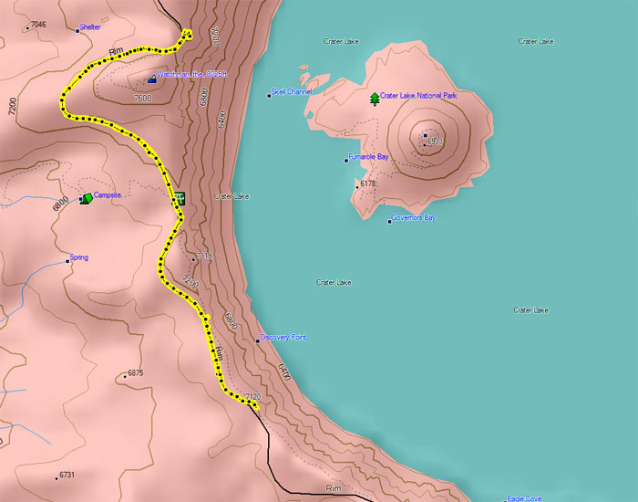
We walked as much of the rim as possible (the trail kind of came and went under snow) and drove one mile down the rim which is as much was was open. Luckily the road had been ploughed much further, it was more that rocks and snow kept sliding onto the road and the next good turnaround was quite a way down the road. You could hike it, hopefully keeping sensible about the whole thing (walk on the side that doesn’t have the big pile of rocks held up by some melting snow). We were in the mood to finally get some exercise after all that rain so we decided we’d see how far we could get after lunch.
As it turns out we did a 5.8 mile out and back, walking out to the watchtower pullout which had been mostly cleared of snow. Combined with the miles of walking at sunrise and along the rim before lunch it turned into a tiring day, but it was very nice to see more of the rim and stretch our legs.
I bought gas at the park – 75 cents cheaper than elsewhere in Oregon. Self-service. Presumably they didn’t charge the state gas tax (they don’t have sales tax, but there’s still a gas tax) since it’s federal property, although they sure did in Yellowstone. This was the cheapest gas so far on the trip. I have no idea if that’s the case in summer – a lot of things like the room rates were heavily discounted (I could normally not afford a room in the rim lodge with a lovely view straight out towards the lake). Usually the roads are more open than they were – they were a couple of weeks behind – but the season still doesn’t really get started until July.
Here's the rim hike. Note we're on the road, not on the nearby trails that were covered with snow.
Friday, June 14th – Crater Lake, OR to Klamath Falls, OR to Lava Beds NM, CA
Steps: The pedometer does a terrible job scrambling around in caves. Oh, well.
I got up at 5:00am, to watch the sunrise from another angle… and the lake was partially frozen over. Apparently it had been very cold that night – traces continued on the lake until about 10:00am – there was just a bit left when we left the park after taking one last wander around.
We drove to Klamath Falls, which is a largish town between Crater Lake and Lava Beds National Monument which was our eventual destination. It’s a little over an hour to either destination – if you want to do both as day trips it’s a perfectly reasonable place to stay. We were able to get some lunch and check in early, and then we hit the roads down to Lava Beds.
I’d been to Lava Beds and was looking forward to it – they have hundreds of lava tubes, many of which you can explore on your own. They sell bump hats and loan flashlights at the visitor’s center but we brought suitable gear since we knew we’d be there. Many of the caves are very lovely and they’re all surprisingly different. At this point we only had about a half day but we explored three caves and had a great time and then went back to Klamath Falls.
Saturday, June 15th – Lava Beds
Steps: The pedometer does a terrible job scrambling around in caves. Oh, well.
We had more time so we did five caves. In some cases we pretty much explored all that’s accessible, in others you could go further if you crawled. Since each cave is different and there are dozens sometimes it’s best to just explore what you can and go onto the next one rather than try to find every possible inch of the one you’re in. Just depends on what you find interesting, I guess. One thing that was very useful was to have a cooler with some food and to basically have a series of light “lunches” every time we got tired – it’s a reasonable workout going through some of these caves even if the total distance traveled is a few hundred feet.
They’re still lovely and the visitors center and information booklets are very much improved since last time – it was much easier to prioritize caves based on the descriptions instead of going in totally blind.
Sunday, June 16th – the big drive home
It takes about six hours to drive home from Klamath Falls. Not much to say there – Mt. Shasta is pretty and you get to drive by it. When we got home pretty much the first job was to mow the lawn – welcome home!
See the rest of Eljay.org - Travel Photos and Trip Reports